


The São Domingos area (Corte do Pinto, Portugal) represents a large sulfide ore deposit in the Iberian Pyrite Belt that was mined primarily for copper and sulfur in the past. The deserted mine and mine wastes are the reason for the production of acid mining drainage, giving rise to abundant efflorescence and crusts of secondary sulfates. Metastable sulfates may temporary sink various pollutants, therefore a quick and reliable method is required for the in situ monitoring of their distribution directly in the field. In this work, we tested a handheld Raman spectrometer equipped with a 532 nm laser excitation for this task. Sulfate crusts and aggregates of the complex composition and various colors were analyzed using this particular spectrometer in the field. Additionally, the collected samples were also investigated through laboratory-based Raman spectroscopy and X-ray diffraction. A suite of hydrated Fe-, Cu-, Mg-, and Al-bearing sulfates and elemental sulfur was detected in the complex mixtures by the handheld instrument which was subsequently confirmed by the laboratory methods. The results show that handheld Raman spectrometers can often provide spectral data at a reasonable quality level fully complementary to laboratory-based methods. Therefore, such systems can be deployed for the monitoring of distribution of secondary sulfates and other minerals in post-mining areas.
Košek F., Culka A., Fornasini L., Vandenabeele P., Rousaki A., Mirao J., Bersani D., Candeias A., Jehlička J. (2020): Application of a handheld Raman spectrometer for the screening of colored secondary sulfates in abandoned mining areas – the case of São Domingos Mine (Iberian Pyrite Belt). Journal of Raman Spectroscopy 51, 1186-1199. (DOI)
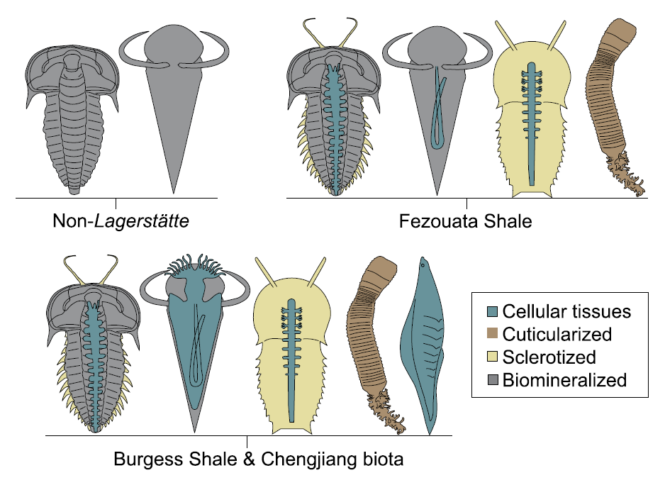 Exceptionally preserved fossils provide deep insight into early animal evolution. For example, the step by step evolution of morphological innovations that ultimately led to the origin of many recent animals was achieved using information from such exceptionally preserved fossils. Each of these sites with exceptional preservation – so-called Lagerstätten – is, however, a subject of specific fossilization bias. This means that at different fossil sites different information is lost during the fossilization process. To understand such information loss is especially important once we want to compare fossils from different sites and infer some general trends. Without knowing fossilization biases, we may end-up comparing apples and oranges. A new study by Saleh et al. (Lukáš Laibl as a co-author) tried to understand such biases. It compared three well known lower Paleozoic Lagerstätten – the Burgess Shale (ca. 505 million years old, Canada), the Chengjiang Biota (ca. 530 million years old, China) and the Fezouata Shale (ca. 479-478 million years old, Morocco). Interestingly, the Fezouata Shale is different from both Burgess and Changjiang. In Fezouata Shale, the soft parts of animals are most commonly associated with partially mineralized and sclerotized tissues. The digestive tract is, for example, preserved mostly in fossils with hard biomineralized exoskeletons (such as in trilobites and echinoderms). For the same reason, the entire soft animals are not preserved in Fezouata Shale. Indeed, most of the animals from Fezouata Shale were either biomineralized (trilobites, echinoderms, gastropods, brachiopods), sclerotized (many types of arthropods) or have had at least external cuticle (various “worms”). On the other hand, Burgess and Changjiang commonly preserve entirely soft animals and also show a higher diversity of different tissue types in particular fossil species. So to sum up, the answer to the question in the title is – yes, but with caution. We have to differentiate between fossilization absence and real absence. Many animals could have lived in the Fezouata Shale environment but were nor preserved because of the nature of the fossilization process. This is likely the case for early chordates that were entirely soft-bodied. On the other hand, the absence of penis worms (priapulids) in the Fezouata Shale is most probably a real aspect of the fauna, since these cuticle-bearing animals would “survive” the fossilization process.
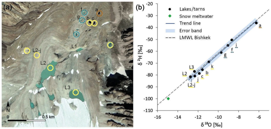 In this study, we characterized glacial meltwater flow through a proglacial area with a focus on proglacial lakes and their hydrological regime and connection to a stream. The studied lakes showed a distinct development throughout an ablation season. For example at Lake 2, the mean daily water-level fluctuation amplitude increased from 0.07 (June) to 0.18 m (August), then dropped to 0.07 m (September). Glacial meltwater flows through the lakes and further downstream through a rock glacier rather fast (0.085 m/s), however only a small portion of water (< 1%) is routed efficiently. The complexity of the site‘s drainage system is supported by varying isotopic composition of water in the tarns situated on the rock glacier, with Tarn a) being the most enriched and Tarn c) the most depleted in heavy isotopes. The results from this study site provide new insights into the complexity of a drainage system connecting a glacier and a stream. Further research of the tarns and subsurface water routing could bring new knowledge about the temperature-related degradation and internal changes of the rock glacier. Considered significant global water storage and influencing hydrological conditions of watersheds, these landforms will certainly draw more attention in near future.
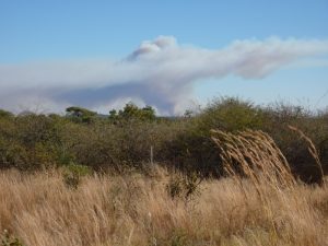 Mercury distribution in topsoils and vegetation samples and temperature-dependent Hg mobilization simulating wildfires have been investigated near a Cu smelter in semi-arid Namibia. The thermo-desorption experiments performed on the representative Hg-rich topsoils indicated that >91% of the Hg was released at ~340°C, which corresponds to the predominant grassland-fire conditions. Despite the installation of a sulfuric acid plant in the smelter in 2015 and a calculated drop in the estimated Hg emissions (from 1301 ± 457 kg/y for the period 2004-2015 to 67 ± 5 kg/y after 2015), the Hg legacy pool in the smelter surroundings will contribute to wildfire-driven Hg emissions until its complete burn-out. Using the Hg spatial distribution data in the area (184 km2), the estimates indicate that up to 303 kg and 1.3 kg can be remobilized from the topsoils and vegetation, respectively.
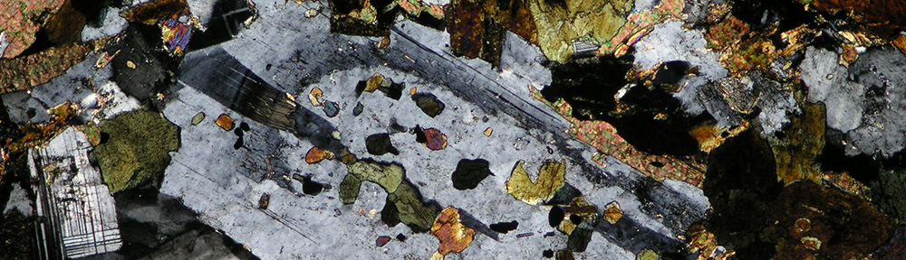
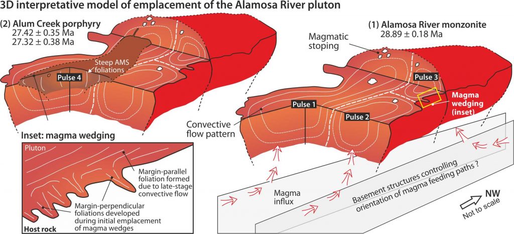 Volcanic calderas are hazardous phenomena associated with cataclysmic eruptions that threaten surrounding nature, human society, and may also affect climate on a global scale. Active calderas are thus carefully monitored, however the underlying magma plumbing systems that store eruptible melt and feed ignimbrite eruptions are still poorly understood. In this paper, we have focused on the extinct Platoro caldera complex that erupted six large ignimbrite sheets between 30.2 Ma and 28.8 Ma in the Rocky Mountains (Colorado), and is associated with voluminous postcaldera intrusions. Using a multiparametric study (field mapping, petrography, radiometric dating, rock magnetism and anisotropy of magnetic susceptibility) of the Alamosa River pluton (29.0–27.3 Ma), we discovered an interesting behavior of magmatic activity that occurred after the main collapse episode. It has been documented that shallow-level magmatic systems of collapsed calderas remain active for another few millions of year, and produce multipulsed intrusions and complex dike swarms. Moreover, such intrusion are further distinguished as resurgent and postresurgent. The former induces ground deformation in form of uplifted domes, whereas the latter has no effect at the Earth´s surface.
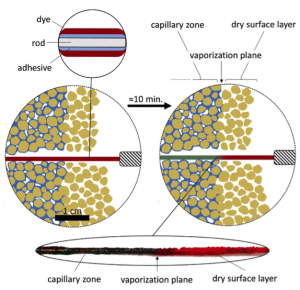 This paper presented a new field method for measuring the depth of the vaporization plane below surface of porous materials. The measuring device consisting of a rod, adhesive, and a water-soluble dye is placed into a porous material. As the pore water dissolves the dye, thus changing the device’s appearance, the dry and wet zones inside of the material can be visually distinguished. The suggested method is minimally destructive as it can be used in holes as small as 2 mm in diameter, relatively fast (typical measurement takes 10 min), and cost-effective compared to other available methods. We have conducted >500 measurements on a range of compact materials (sandstone, arkose, tuff, rhyolite), mostly on natural outcrops in humid continental, warm and cold semi-arid, and desert climates. It has been also shown that the method can find use in studying water presence in building materials or soil. We believe the method will give the scientific community a whole new perspective of water distribution especially in the near sub-surface of porous rocks for studying salt and cavernous weathering, lithophilic organisms, or water dynamics in both natural and artificial porous materials.
 A unique exposure of the Štramberk Limestone in the Kotouč quarry was investigated by multidisciplinary approaches to clarify the age and paleoenvironmental conditions. Integrated stratigraphy (magnetostratigraphy, 87Sr/86Sr isotopes from belemnites, δ18O and δ13C stable isotopes from bulk rock, microfossil and ammonite assemblages) revealed an early Berriasian age and refused the presence of the Jurassic/Cretaceous boundary interval. The δ18O isotope signal from bulk rock together with microfossils distribution (calpionellids, calcareous nannofossils) show temperature oscillations throughout the studied successions. Boreal influences were detected by ammonites, supporting also climatic variations within the earliest Cretaceous. The limestone microfacies then revealed that all parts of a carbonate reef have been preserved in the quarry: slope, platform margin reefs, sand shoals, and possibly also patch-reefs in the inner platform.
 Since the pioneering works of early 20th century, Late Cretaceous sandstones along the Lusatian Fault were interpreted as sourced from the West Sudetic Island. However, the original concept that basement of the Lusatian Block directly supplied a clastic material to the Late Cretaceous shores and deltas, has been recently challenged. New LA-ICP-MS U–Pb dating of detrital zircons and heavy mineral analysis of Permian, Jurassic, and Upper Cretaceous formations revealed diachronous basin formation and subsequent inversion by reactivation of major faults in the northern Bohemian Massif. In turn, the Middle Jurassic–Early Cretaceous sedimentary cover of the Lusatian Block was redeposited by its later uplift and unroofing. This paper proves that the Bohemian Creatceous Basin is not only an excellent archive of paleoclimate changes, but its record may contribute to deciphering relatively enigmatic post-early Permian tectonosedimentary history of the surrounding basement areas.
 An intriguing example of a late Precambrian chert-graywacke mélange was explored by Jaroslava Hajná and colleagues in the central Bohemian Massif (mélanges are chaotic rock units that contain mixed exotic blocks and typically form along the active plate margins). A detailed field, geochronologic, and geochemical study revealed two types of chert (pelagic and those with a terrigenous component) that were mixed together during a large-scale submarine slide on an outer slope of oceanic trench. This case turned out as a quite unusual deep-marine succession and led to a definition of a new type of mélange. Published in a special issue of Gondwana Research devoted to the