


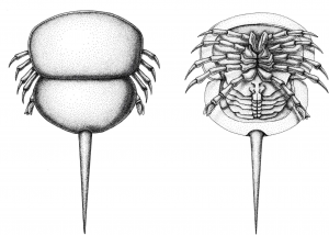
 Today’s horseshoe crabs are often described as living fossils, mostly for their early appearance in the fossil record and their supposedly conservative morphologies. Nevertheless, after a careful investigation, one can find even peculiar species among this group of spider’s close relatives. Indeed, the recent marine representatives of horseshoe crabs (three genera, four species) are all members of one surviving clade called Limulidae. Deep in the past, during the Paleozoic and Mesozoic, some horseshoe crabs evolved into quite different morphologies and explored various environments. One group called Belinuridae comprises mostly late Paleozoic species that explored freshwater habitats. Lustri, Laibl and Bicknell, in their paper published recently in PeerJ (Lustri et al. 2021), redescribe small (about 3 cm long) and morphologically simple belinurid Prolimulus woodwardi. This species has been originally described by Antonín Frič, back in 1899, from the famous sapropelic coal of the Plzeň Basin. Based on numerous well-preserved specimens, the authors describe and clarify the species morphology, including such details as opercula and chelicerae. Phylogenetic analysis shows that Prolimulus is, together with some other morphologically similar genera, a member of highly paedomorphic (i.e., resembling juvenile stages of others closely related taxa) ingroup within Belinuridae. This discovery is further corroborated by morphometric results and by the fact that there are epibionts attached to some Prolimulus specimens. The presence of attaching organisms on the exoskeleton of Prolimulus suggests, that these small specimens are individuals that already stopped or significantly slowed the molting of their exoskeleton. In other words, they are adults that retain juvenile morphology. Such morphological and developmental plasticity, together with a successful exploration of freshwater habitats illustrates the horseshoe crab’s ability to adapt to various environmental conditions in the deep past.
Lustri L., Laibl L., Bicknell R. 2021. A revision of Prolimulus woodwardi Fritsch, 1899 with comparison to other highly paedomorphic belinurids. PeerJ 9, e10980. (DOI)
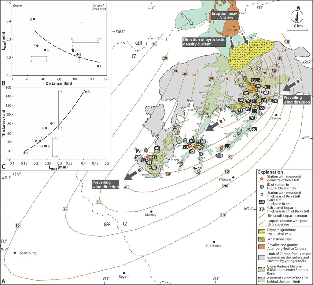 The famous Bělka tuff is a widespread pyroclastic layer preserved elsewhere in the central and western Carboniferous late- to post-orogenic basins. This tuff represents a unique stratigraphic marker documented from tens of boreholes and numerous black coal mines within a large area between the southern edge of the Pilsen Basin in western Bohemia to the eastern part of the Kladno-Rakovník Basin over a distance of 100 km. However, its volcanic source was until now unclear. In a new study by Tomek et al. published in International Geology Review, a multidisciplinary approach using the LA-ICP-MS U/Pb zircon dating, thickness and grain size distribution analysis, and volume calculation suggested that the source volcano is the Altenberg–Teplice Caldera located at Czech-German border in the NW Bohemian Massif. In detail, this volcano erupted a major caldera-forming ignimbrite eruption with an estimated volcanic explosivity index 7 (out of 8) at 314 Ma. The pyroclastic density currents travelled over a distance of ca. 60 km towards the area of Oparno valley (Porta Bohemica). From here, the northeastern winds distributed the volcanic ash cloud towards the southwest, where the ash was deposited in the sedimentary basins. The isopach reconstruction indicate that for instance in Regensburg (Germany), there was a 10 cm thick ash layer that originated from the Altenberg–Teplice Caldera nearly 220 km away.
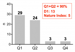 Despite the pandemic situation in 2020, the researchers of the Center for Geosphere Dynamics were highly productive. A total of 59 papers have been published (printed + in press) in 2020. Papers published in the first and second quartile journals according to Web of Knowledge accounted for 90% of the total. The numbers also include 13 papers in the D1 category and 5 papers in the Nature Index journals.
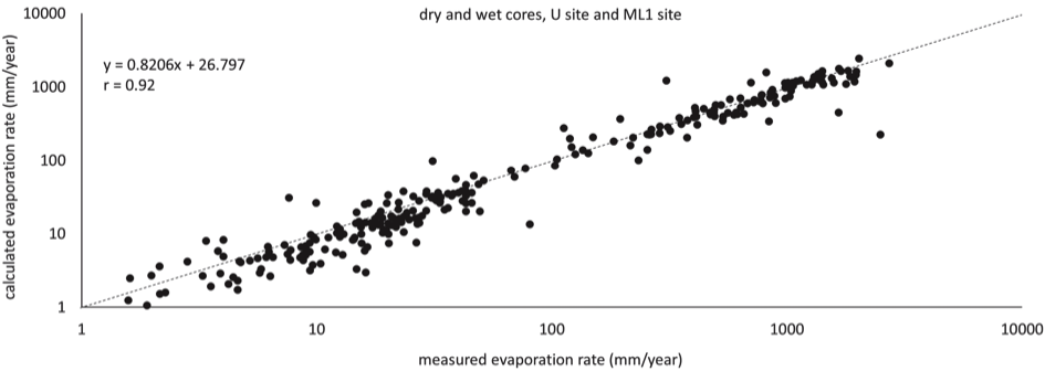 Evaporation from porous rock plays an important role in weathering and biological processes. Despite its importance, evaporation from porous rocks has seen little scientific focus. We present a study on evaporation from bare sandstone, one of the most common rocks affected by weathering. A new method that measures the evaporation rate from the surfaces of sandstone samples under field microclimate was developed and tested. Also, a simple calculation of 1D evaporation rate from bare sandstone surfaces based on Fick’s law of diffusion is presented. The measurement was performed using sandstone cores in a humid continental climate and measured on a roughly monthly interval for about 1 year. For the calculations, a laboratory-measured water-vapour diffusion coefficient of the sandstone, in-situ seasonally measured vaporization plane depth (depth below the surface where liquid water evaporates), and values of air humidity and temperature were used. It was found that the most important factor controlling the evaporation rate was the vaporization plane depth, while seasonal and spatial changes of air humidity and temperature were of lesser importance. The calculated evaporation rate reasonably follows measured values with Pearson correlation coefficient r > 0.81. For its simplicity and the small number of parameters required, the proposed method has the potential to improve knowledge of weathering and living conditions of endolithic and epilithic organisms.
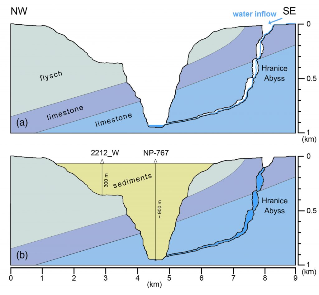 Extremely deep freshwater filled cave systems are common in karst systems globally. The origin and evolution of such caves are usually attributed to hypogenic (bottom‐up) processes, in which acidic groundwater dissolves limestone from below. A combined geophysical survey was applied to improve a subsurface image of semi-buried karst morphology in the close vicinity of Hranice Abyss (HA). Based on the results of electromagnetic surveying (AMT method), suggesting a deep disintegration of the carbonate sequence, a new possible depth of ~0.9 km of HA was estimated. An alternative hypothesis, suggesting predominantly epigenic evolution (top-down process) of the HA evolution, was introduced. Furthermore, an applicability of individual geophysical methods and their combinations has been evaluated on the basis of an integrated interpretation of geophysical data. This research attracted attention of media abroad (
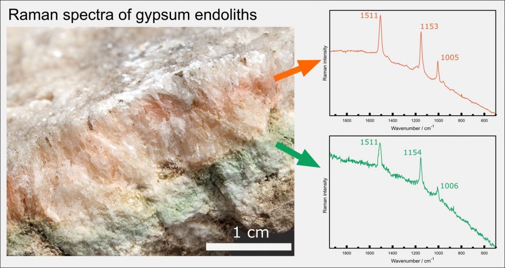
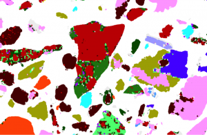 Automated mineralogy has been used to quantitatively determine the contaminant partitioning in the soil particulates originating from heavily polluted mining/smelting sites. This method provides faster data acquisition, the full integration of the quantitative EDS data and better detection limits for the elements of interest. AutoSEM was found to be a useful tool for the determination of the modal phase distribution and element partitioning in the metal(loid)-bearing (As, Cu, Pb, Zn) soil particulates and will definitely find more applications in environmental soil sciences in the future.